As El Niño Splits the Map, Agricultural Risk Keeps Moving
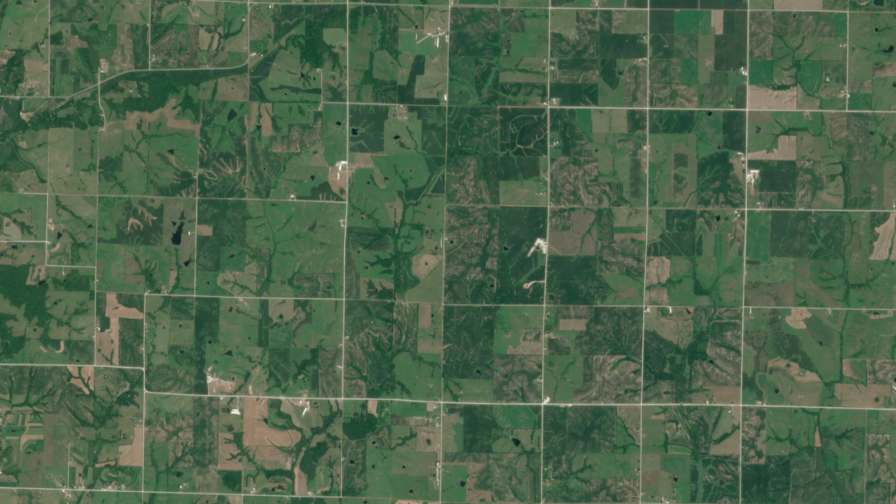
Farmland in Iowa, USA, captured by the EarthDaily Constellation in April 2026.
The first question is how strong this El Niño gets. NOAA’s Climate Prediction Center reported in its August 13 outlook that the developing 2026 El Niño event had a greater than 90 percent chance of becoming very strong during the Northern Hemisphere fall and winter, with a 69 percent chance of reaching a strength exceeding previous El Niño events dating back to 1950.
A strong El Niño can produce a sharply uneven agricultural picture. Some major growing regions turn wetter, others drier, and crop conditions vary considerably within a single country.
This has triggered a surge in demand for ag insurance from farmers worried about their crops.
For insurers this is a mixed blessing. The demand is a real commercial upside in what would otherwise be a soft year, but it arrives for the worst reason: buyers crowd in exactly when expected losses are highest, which is adverse selection at market scale.


This also poses a very big challenge for insurers, who need to make sure they have a contained loss ratio. Higher weather volatility means higher risk, which would normally push a carrier to pull back from the market. Instead of exiting the market completely, insurers are defending their balance sheets three ways: capping local liability limits, transferring more risk to reinsurers while the broader reinsurance market is soft, and rebuilding reserves ahead of the claims they expect.
For that reason some companies are scaling back their coverage in high-exposure zones. In vulnerable markets there is a shift from aggressive competition to defensive, structural risk management. Insurers are bracing for highly uneven losses. For instance, companies expect drought to hit Central America’s Dry Corridor and parts of Asia, while anticipating heavy destructive flooding across portions of the Andes and the U.S. South.
This season is already showing why. Canada’s crops have held up through a drier July, southern Brazil is dealing with excess rain, and rainfall deficits remain concentrated in parts of India.
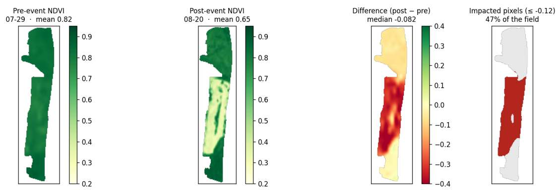
Image shows a partial crop failure due to partial flooding of the field due to bad drainage and excess rain. Source: EarthDaily analysis
At Underwriting, Set the Starting View
Insurers are refusing to expand coverage in high-risk zones to avoid accumulation, and in a strong El Niño those zones are fairly predictable. Drought concentrates in Central America’s Dry Corridor, in the north and northeast of Brazil (the Nordeste and the Amazon, while the south turns wet), and in the east and northeast of India.
Today there are extensive checks and audits with more policy refusals. Carriers are willing to accept a smaller but healthier book, which in practice means an overall drop in coverage. Satellite observation fits these audits well, a low-cost way to confirm they are not writing cover on a crop that has failed consistently in the past, and the current season already shows signs of stress.
As an example, in Brazil insured agricultural area has fallen 76% versus prior years, dropping below 3% of farmland in some regions. That reflects both a freeze in government premium subsidies and insurer caution around climate volatility.
Insurers have set stricter cut-off dates for seasonal policies, to stop farmers buying emergency cover as the forecast hardens.
Prices have not moved yet. In some countries the season has already begun, so that risk is now on the books at current rates. But the industry leaders expect that if the heavy claim experiences that are expected for this season are realized, this will trigger a sharp rise in prices for the next season.
Insurers also expect friction in the newer markets. Farmers buying out of fear often expect to be made whole for their best-ever harvest, so carriers have to reset those expectations and set clear limits.
At Portfolio Level, Track Financial Exposure
Because a severe El Niño can trigger simultaneous, correlated losses across different continents, local insurers cannot hold all of that risk alone. Reinsurers act as an ultimate shock absorber.
A national rainfall number is the wrong metric for an insurer. By August 19, India’s monsoon rainfall was still 13 percent below normal, and that average buried details that matter. The east and northeast were 25 percent below normal, while Central India held near normal. Averages don’t pay claims; concentrations do.
The in-season question is: “How is my monsoon, the one that is falling on my insured acreage at this growth stage across my largest accumulations?” Several parts of the book bending at the same time in the same direction can turn a manageable season into a reserving problem.
Daily satellite revisit answers that at the resolution the question demands. Field-level vegetation indices show which insured crops have dropped out of the historical band, where stress is clustering, and where a region you had written down is quietly recovering. That is a reserving timing input, a reinsurance timing input and a map of where to send adjusters first, weeks before the first claim is made.
A book that looked stressed in July can recover by September, or the reverse, as crops move through their sensitive windows. The policy is fixed at binding. The insurer who can see the risk shift in season is the one not surprised at harvest.
For Parametric Products, Test the Trigger
Agriculture index and parametric insurance bring the relationship between weather and crop outcome into particularly sharp focus. A weather trigger captures only part of what is happening to the crop. The effect of a dry spell depends partly on how much moisture was already available, while the impact of rain changes as the crop progresses through the season. A threshold being crossed does not always line up neatly with the loss that follows.
Southern Brazil illustrates the issue from the other direction. Rio Grande do Sul and Paraná account for approximately 80 percent of Brazil’s 2026 wheat harvest. Excess rain is currently the concern across this major producing area, and the eventual consequences for yield, and grain quality may become clearer only as the crop develops.
The gap between the policy trigger and the eventual crop loss is basis risk. Historical back-testing can show how closely a trigger has tracked actual crop outcomes in previous seasons.
For parametric insurance, the terms are locked at binding. A trigger, its threshold and its payout curve are fixed when the policy is written, and none of it can be retuned in September because the monsoon disappointed. All the room to get it right is upfront, in how well the index is designed and back-tested before the season.
In-season, none of this changes the bound contract, but the same field-level observation is still useful. The trigger sold is fixed. What the crop shows still shapes next year’s trigger.
At Claims, Focus the Assessment
Everything the portfolio has been signalling arrives at once when the season ends. In regions where a strong El Niño lands hard, losses do not trickle in. They hit as a correlated wave, and that wave is what tests an agricultural insurer’s claims operation. This is where the accumulation risk from earlier in the season becomes a cash outflow.
Loss adjustment expense is one pressure point. A strong El Niño can trigger simultaneous regional crop failures, and the pool of certified agricultural loss adjusters does not expand to meet them. Field travel becomes more difficult and one adjuster can only cover so many farms in a day, so files stay open longer and cycle time and expense rise together.
None of these remove the need for fieldwork, but earlier visibility changes what the fieldwork costs. A pre-loss and in-season satellite record lets a claims team triage before adjusters deploy: rank fields by expected severity, send scarce capacity to the largest real losses first.
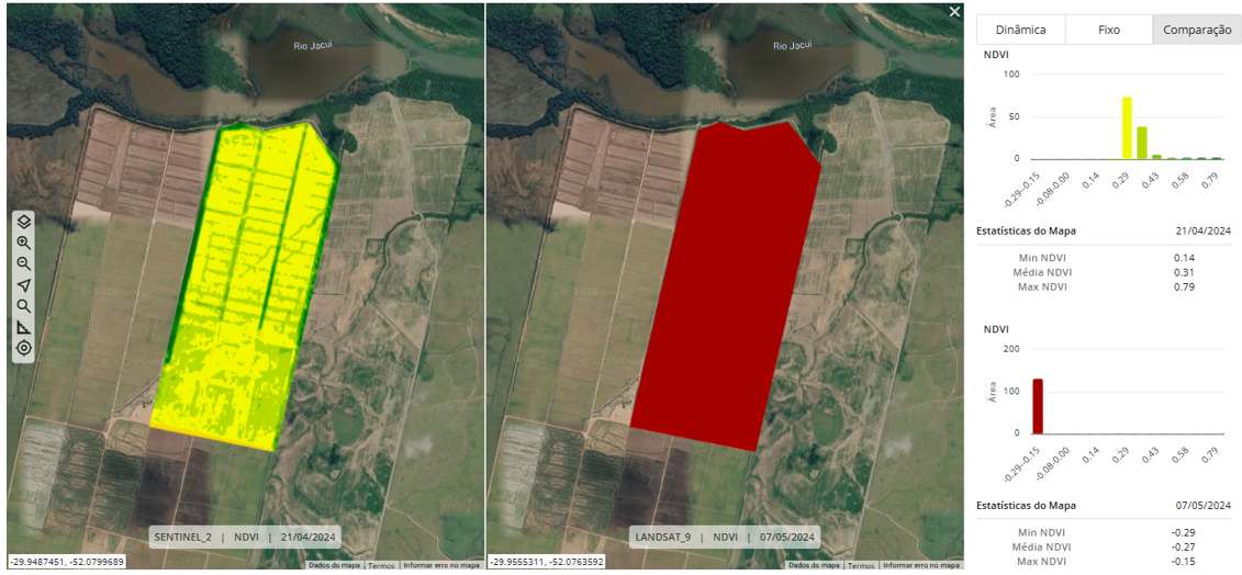
Image shows the heterogeneous state of the field with healthy development before the flood event and the complete loss after it. Source: EarthDaily analysis
A time-stamped history of each field condition before the policy is accepted can provide evidence when investigating anti-selection or exaggerated claims. An objective biomass trajectory can help distinguish weather-related deterioration from other causes.
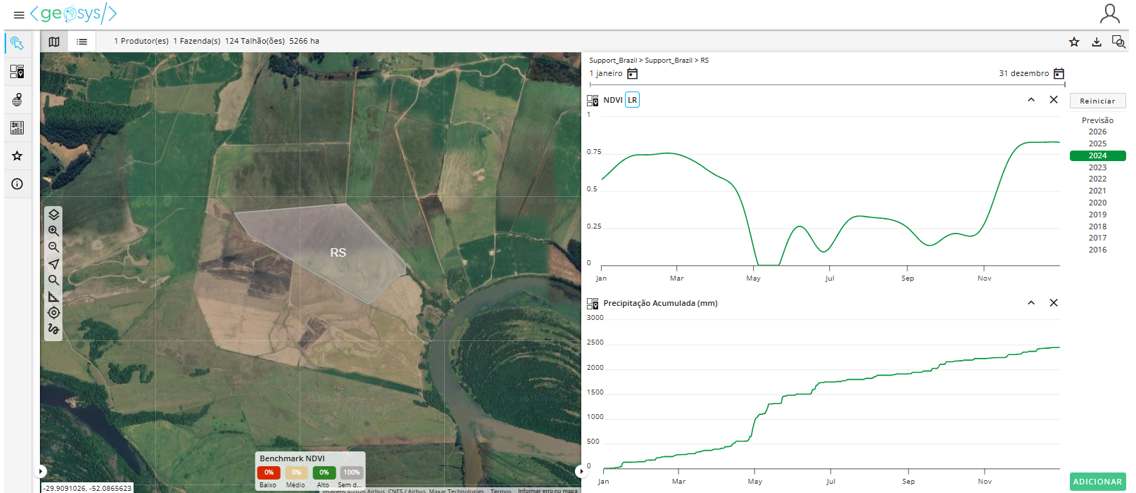
Image shows the time series of the healthy development of the crop until the excess of rain at the end of April and subsequent loss due to excess of rain. Source: EarthDaily analysis
There is always the cloud problem; El Niño storm systems can hold cloud coverage over regions for weeks, blinding standard optical imagery at the moment verification matters most. One way to manage this is through high-revisit constellations and radar that sees through clouds and keeps a usable signal when lower-revisit optical imagery goes dark. Pre-event baselines also let the first clear image do more work.
The current El Niño will generate more forecasts, market reactions and regional crop signals over the coming months. Financial markets are already demonstrating how quickly climate foresight can be turned into action. Agricultural insurers can use that same window throughout the risk cycle: establishing the baseline, watching where exposure concentrates, translating the crop deterioration into financial exposure, testing whether triggers continue to track crop outcomes and focusing assessment where damage emerges.
The policy may be priced once. The agricultural risk behind it keeps moving.
Get The Newsletter Today!